Ancient City of Sigiriya
The recent history of Sigiriya village goes back to the era of the 3rd century BCE. However, according to the folk legends and recent dialogues between archeologists, historians, and some experts, one may be able to believe that this place must have been used by the prehistoric King Ravana at least 50 centuries before the 3rd century BCE. Those shreds of evidence found in the Ravana Watha (Palm Leaf Book), are described by some scholars & historians who have an inquisitive interest in searching for the lineage of the fortress castle.
Certainly, the name “Sigiriya” become popular after founding the famous Lion Rock Castle in the 5th century. But the place had been used as a Buddhist monastery long before the Rock Castle come into existence. The village must have been there since the early days but at a reasonable distance from the rock making sure not to disturb and also to feed the monks who are from the monastery.
The Lion Rock Fortress

Prominent facts about the Fortress, UNESCO World Heritage, and the 8th Wonder of the world
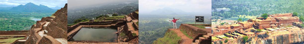
Sigiriya, the Lion Rock Fortress is 360 meters above sea level and 200 meters above the surrounding plain. It is about 80km south of Anuradhapura City, which stands in the very central part of the Island. Sigiriya village is encircled by mountains, forests, and manmade lakes. It is truly a fortified Royal Capital of the 5th-century King Kassapa (475-497 CE) commonly known as a patricide, however, he is a unique character and creative genius. History says that he built his Palace on the top of this huge bolder rock and formed his City surrounding the rock. At the top of the Rock can see the foundation bricks of the Royal palace and the remaining of the other subsidiary buildings covering an area of three & half hectares.
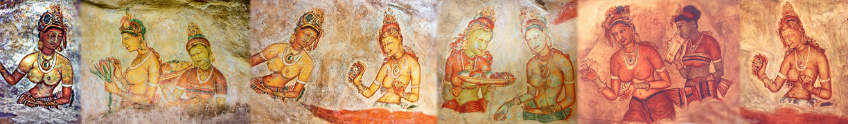
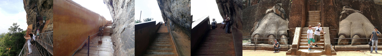
The grandeur of Sigiriya lies in its distinctive features such as the Royal Palace on the summit of the rock, the skillfully planned and engineered ascent to the palace through a brick-built massive lion figure, and beautiful paintings of celestial nymphs drawn on the plastered walls. The remaining paintings are in an inaccessible cave halfway up the rock, which the visitor can reach only by the modern spiral stairway, on the highly polished mirror wall of the gallery full of graffiti, visitors to the rock who might come to see the paintings might have left behind their thoughts and emotions during 8th to 13th centuries. The boulders with caves of boulder garden at the foot of the rock are scattered unevenly on the western side. Symmetrically and geometrically planned water gardens, a mathematically planned fortification layout consisting of 2 moats, and the rampart system surrounded the entire city with accessible gateways from 3 sides north, west, and south in which two gates of north & south are large enough for elephants and vehicular traffic
In its totality, therefore, today Sigiriya provides us with a classic example of a unique concentration of 5th-century town planning, landscaping, gardening, engineering, hydrologic, technology, architecture, art, and literature, thereby forming a cultural museum of the 5th-century Sri Lanka.
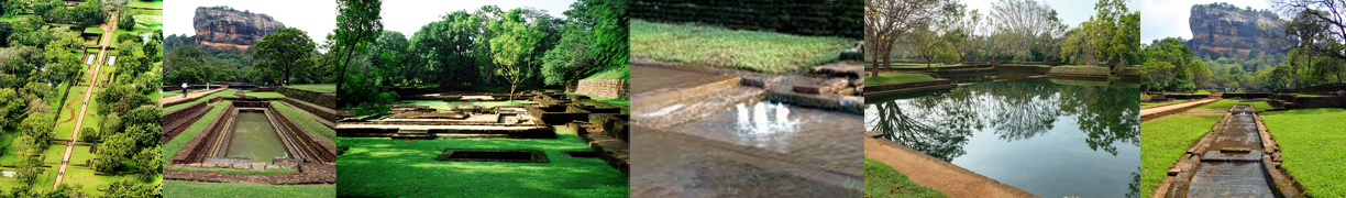
Apart from the existing and fascinating rock at Sigirya, a visitor who enters by the Western entrance through a drawbridge can notice that there are four types of garden elements, Water gardens, Boulder Gardens, Terrace Gardens, and Palace Gardens.
The Water Gardens
Water gardens can be divided itself into three parts demarcating their boundaries by stepped terraces. The first part of the water garden that lies close to the Western entrance is divided into two equal parts by an axial pathway leading toward the rock. On either side of the pathway are built four symmetrically planned ponds.
The most exciting part of the water garden is its’ second portion which can be called the “Fountain Garden”, the western half of which has two long and deep pools with stepped cross-sections. Shallow serpentine streams paved with marble slabs drain into these pools. These serpentines are punctuated by fountains made of circular limestone plates with symmetrical perforations. The underground water conduits feed these fountains and operate purely on the principle of gravity and pressure. Even today these fountains operate during the rainy season.
The third portion of the water garden is an extensive area on a higher level, access to which is provided with a flight of steps, place almost at the center of the terrace. To the north is a large spectacular octagonal pond at the base of a towering boulder on the western side of which is a horizontally cut drip ledge indicating that it once had some sort of structure of the remains of a “bathing pavilion”
The water garden ends up with a massive brick and stone wall pierced by a wide entrance with a flight of steps leading to the boulder garden. To the North and South of the fountain, gardens lie two moated islands on which there seem to have been well-planned structures perhaps summer palaces of the water gardens. The excavation of the southern moated island has revealed a central structure surrounded by a single row of pedestals that once held columns, forming a colonnade around the building. The entrance to this structure is marked by a moonstone which is still in site.
The Boulder Garden
The Boulder garden is situated on a higher level than the water gardens. The natural beauty of Sigiriya lies in this boulder garden which is entirely organic and asymmetrical, comprising several winding pathways, some leading to the main rock. It seems that the human hand has never attempted to alter or remove the existing positions of these boulders but utilized them for human needs by constructing buildings or pavilions set upon them. Today what we see as steps and drains or honeycombs of holes on the side or tops of these boulders are in fact the foundations or footings of ancient brick walls and timber columns and beams. But unfortunately, none of these structures on the boulders survive today.
Many of these boulders have rock shelters beneath them originally fashioned by the early lay devotees and offered to early Buddhist monks. Some of these rock shelters still bear traces of paintings. A noteworthy feature in this area is the use of some boulders to form an Audience Hall which has a flattened summit, on which a large 5 meters long throne is carved out of the living rock showing the degree of rich technological skills of the stone masons of the day. The boulder adjoining the ‘’Audience Hall’’ provides another example of how the ancients utilized boulder tops to build cisterns. Another interesting example of a boulder being used for meeting human needs is the ‘’Preaching Rock’’ the summit of which exhibits a honeycomb of port holes indicating a structure over the boulder.
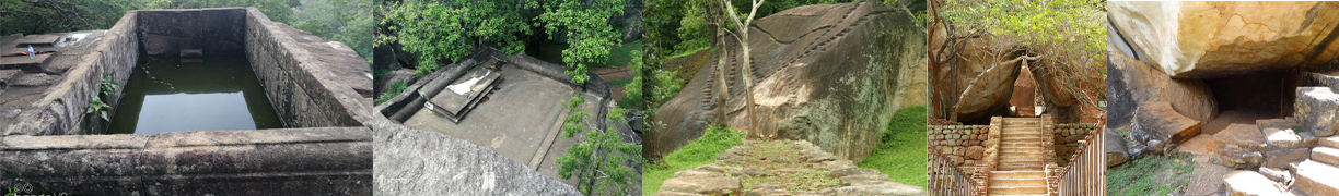
The Terrace Gardens
The terrace gardens have been fashioned out of the natural hill at the base of the Sigiriya rock. These terraces are formed by means of rubble retaining walls. On the west, terrace garden lie the brick-built staircases leading the way up to the summit of the rock through the gallery and the precipitous side of the main rock. This staircase first leads onto the ‘’Lion Staircase Plateau’’ where we can see the remains of a great brick-built lion figure which gave Sigiriya its name.
The Palace Garden
Palace garden elements at Sigiriya are located on the summit in the form of the terrace and rock-cut water pools designed as the domestic garden of the palace of the King
The history of Sigiriya extends from about the 3rd century BCE to the 19th century CE. In its earliest phase, it was a monastic settlement. In the 5th century AD, it became the Capital of Sri Lanka for a brief period, under King Kassapa I (475-497 CE). This was the major constructional phase of Sigiriya during which the present name came into being. Subsequently, after Kassapa’s death, it was turned back into a monastic settlement. This post-Kassapan period seems to have lasted till the 13th century. Sigiriya Graffiti prove beyond doubt that it was the paintings that become the main attraction of Sigiriya during the period. The visitors from all over Sri Lanka had come here as pleasure-seekers and their thought and emotions were recorded in the Graffiti. Prof: S. Paranavithana (1940-1956) deciphered nearly 700 of them. They are among the earliest literary compositions in the Sinhala language preserving the form of day-to-day poetry rather than official inscriptions or religious literature. After the 13th century Sigiriya disappears for a time from the history of Sri Lanka until in the 16th or 17th century it appears as a distant outpost (16th-19th centuries). The last phase at Sigiriya begins with the modern recovery in the 1830s by antiquarians and archaeologists, the first modern reference to Sigiriya being that of Mr. Forbes in the 1830s. The first excavations were carried out by HCP Bell. The first Archaeological Commissioner of Sri Lanka in the 1890s and the work continued off and on ever since.
The Sigiriya Cultural Triangle Project, one of the six projects of the UNESCO- Sri Lanka Cultural Triangle Program was inaugurated in January 1982. This project is administrated by two agencies.
The University of Kelaniya Archaeological team (archaeological direction, excavation, documentation, and research) and Messrs. Selvarathnam & Perera Architectural Consultants (conservation and layout and peripheral area development) and presided over by the Director-General of the central cultural fund. The principal objectives of this project are the excavations, conservation, and landscaping of the Sigiriya complex. This project when completed will give us a better understanding of the history and character of this unique site and make its various aspects more comprehensible to the thousands of visitors who come to see Sigiriya, the lion mountain.
By Eranga Suneth Jayasinghe * Ref – Lecture notes from Prof: HT Basnayake of CTB (SLTDA) / NTGL course in 1998.