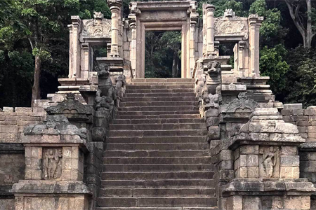
Yapahuwa [Sinhala: යාපහුව] ヤーパフワ
The Rock Fortress is located in the Mahawa Divisional Secretariat in the North Western Province of Sri Lanka. It is about 140 km northeast of Colombo on Anuradhapura highway via Kurunegala, approximately about 8 km east of Mahawa road from Dhaladhagama Junction.
Yapahuwa takes a prominent place in history. The Bodhivamsa (a chronicle) mentions that Yapahuwa was known as Sundara Giri Pavuwa in the 3rd century BCE during the reign of King Devanampiyatissa. The place was known as Subhavala or Subhagiripura when General Subha converted it into a fortress for security reasons. In the Dhaladda Pujavaliya (a chronicle) it is known as ‘Ayo Parvata’.
Yapahuwa, the 4th official capital of Sri Lanka in the late 13th century in the years between 1273 -1284, Palace was built on huge 90 meters tall boulder rock by King Buvanekabahu I (1272–1284) in the year 1273. Many traces of ancient battle defenses can still be seen at Yapahuwa. On top of the rock are the remains of a Stupa, a Bodhi tree enclosure, and a rock shelter cave used by Buddhist monks in the late Yapahuwa period. There are several caves at the base of the rock. In one of them, there is a shrine with Buddha images. One cave has a Brahmi script inscription. At the southern base of the rock, there is a fortification with two moats and ramparts. In this enclosure, there are the remains of a number of buildings including a Buddhist shrine. There is also a Buddhist temple called Yapahuwa Rajamaha Vihara built during the Kandy period.
The Tooth Relic of Lord Buddha was brought here from Dambadeniya (3rd Capital City) and kept in the Tooth Relic Temple built at the highest place. The Sacred Relics were taken away to south India by Pandyan invaders and then recovered Tooth Relic in 1288 by Parakkramabahu III the Great (1287–1293).
Jaffna [Sinhala: යාපනය] ヤーパナヤ
Jaffna is the northernmost city, and around this peninsula, there are many small islands in close proximity connected by bridges to the mainland. Totally flat land almost at sea level in altitude made of limestone mostly. Before the civil war, Jaffna was the second largest populated city after Colombo with multi ethnicity including Sinhalese and Moors apart from the majority of Tamils. Quite a silent city with busy daytime but very early night-time may be the influences of scariness suffered for the last 30 years under the LTTE control, which may have become a habit of life.
There are many interesting places to visit in Jaffna; Dutch fort, Nallur Kovil, Nainathive, Delft Island, Katsurina Beach, Bottomless well, Kadurugoda Buddhist ruins, Dambkola Patuna Buddhist temple, etc,
Trincomalee [Sinhala: ත්රිකුණාමළය / Gokanna : ගෝකන්න ] ツリンコーマレー
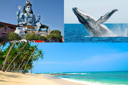
Trincomalee is famous for its’ beautiful beach Nilaveli, Pigeon Island marine reserve, Whale watching, Hindu Temple, Dutch Fort, Ancient Buddhist Temples, Hot water wells, etc. The city is located about 108 km northeast of Dambulla city and is the Capital of the Eastern province. There is about 134 km from Batticaloa, the other famous beach in the eastern province.
The strategic location of the Trincomalee Harbor and the Airport makes greater tension among the western powerful nations and the eastern coming up powers to lay their baby, especially in this century. However, this harbor was an important gateway to Island for both the western and eastern traders from a very early period. Natural deep water harbor has attracted seafarers like Marco Polo, Ptolemy, and sea traders from China and Eastern Asians since ancient times.
The conversion of Gokanna between “Tirukonamalai” first appears in a Tamil inscription dated to the 10th or 11th century AD. The ancient Buddhist temple at Gokanna called Sri Gokanna Vihara built during the reign of King Mahasen (276-303) was one of the earliest religious construction in Trincomalee. Being on a rock it was called Vehergala. Temple was expanded by King Agbo (718-724 AD). In the 10th & 11th centuries, Hindu influences took place to a greater extent and the Portuguese demolished both Buddhist and Hindu temples. The Portuguese built the biggest fortress at Trincomalee in south Asia.
Matale [Sinhala: මාතලේ] マ ー タレー
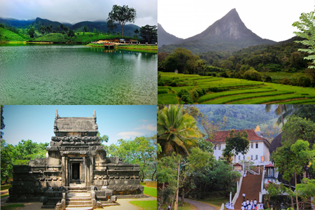
Matale is a village and small city with a very mild temperature and a comfortable climatic system for its flora and fauna. It is only 25 km north of Kandy where everyone should pass Matale when traveling to Dambulla from Kandy. Matale has its pride in many historic records. The Aluviahare temple; documented the Buddhist teaching and dharma (THRIPITAKA) for the first time in the 1st century BCE, and in the English period; started a rebellion war against foreign rulers from Matale Aluviharaya. And this village produces most of the world-renowned Ceylon black paper and other spices. In tradition, Matale is known to everyone as a very beautiful village and for Sinhalese beauty girls.
There are a few places worth visiting in Matale; Archaeological sites; Nalanda Gedige, Aluviharaya Raja Maha Viharaya, Meemure unspoiled hidden village & Sembuwatta Lake, Riverstone Gap, Bambarakiri Ella (falls), Hunasgiriya Water Fall, and National Spice Garden are some of them.
Nuwara Eliya [Sinhala: නුවර එළිය] ヌワラエリヤー
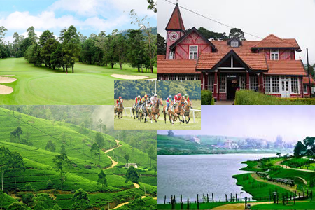
Nuwara Eliya city is said to be a new village founded by the British during their colonial rule of the country. The city was first founded by a Scottish farmer Mr. Samuel Baker, he started English vegetable farming around the city. And later began to develop with the coffee and tea plantation rapidly. The city was more interestingly home to the British hunters who hunt and killed many wild animals as a hobby during the day. The altitude of the city is 1868 meters and is surrounded by mountains including the tallest Pidurutalagala (2524 meters) making its temperature at the lower level at about 15 °C on average and during the night goes down as low as 5-6 °C in December season. The best season to visit is March, April & May but all year round tourists are full in Nuwara Eliya. Sudden climatic changes like in England and the city is a bit like a village in England.
Nuwara Eliya is a very popular destination among both local and foreign travelers due to its cool climatic condition and the natural beauty of the landscape. From Nuwara to Eliya could easily visit World Heritage Horton Plains and the best place to see a few endemic birds.
Places to see in Nuwara Eliya; Red post office, Victoria Park, Racecourse, Hike to Piduruthalagala, Hike to Kirigalpotta, and the Tomb of Captain Thomas William Rogers (Who killed over 1500 elephants just to enjoy, who was killed by lightning at the age 28 years old in Nuwara Eliya. His tomb has striking by lightning up to the present day, evidence is the broken cover slab of his Tomb), Oliphant Estate, Horse Riding to Single Tree Hills, Birding in and around Galway Land Sanctuary, visiting Ceylon Breweries, Royal Golf Club, and Hakgala Botanical Gardens are some of them.
Bandarawela [Sinhala : බණ්ඩාරවෙල] バンダーラウェラ
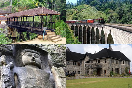
Bandarawela is the second largest town in the Badulla District which is 28 km (17 mi) away from Badulla city. Bandarawela is 44 km away from Nuwara Eliya and only 15 km from Ella. Thanks to its higher altitude, compared to surrounding locations, Bandarawela has milder weather conditions throughout the year making it a tourist destination for relaxation.
Ella (Sinhala: ඇල්ල) アッラー
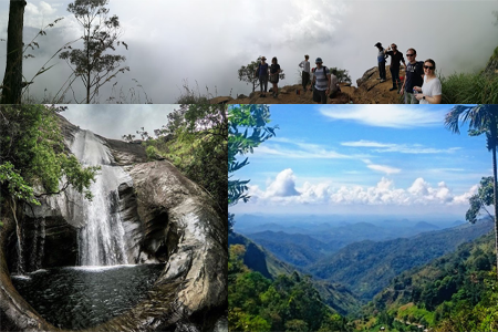
Ella Is a small Village in Badulla District of Uva Province of Sri Lanka. It is approximately 95 kilometers north of Tissamaharamaya, and about 60 kilometers southeast of Nuwara Eliya. Little town amidst the towering peaks lies at an altitude of 1,041 meters (3,415 ft). Year around cool climatic conditions is the best for Ella and adventurous activities like mountain hiking, walking in villages, cycling around, and bathing in natural pools by the waterfalls are some of the joyful experiences may enjoy.
The view from the Ella gap is simply breathtaking, this is the ideal place to see miles upon miles of countryside south Sri Lanka. You could even see up to the silver lining of the ocean on a clear day. Places to visit;
- Rawana Falls
- Demodara Railway Loop (A loop in the rail track)
- Mini Adams Peak
- 9 Arch Railway Bridge
- Rawana Caves & Ancient Rock Temple
- Dowa Temple
Katharagama [Sinhala: කතරගම ] カタラガマ
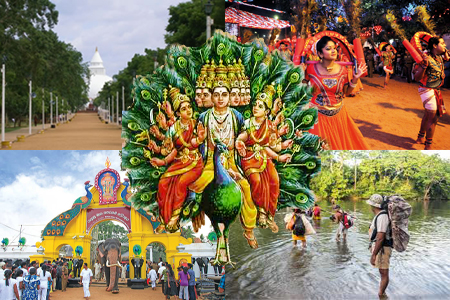
Kataragama is a village in the south and is the home of God Sakndakumara alias God Kataragama, who has been venerated by almost all the people in Sri Lanka. This mighty warrior God believe to have the superpower to eliminate injustice and he is the symbolic protector of all kinds of vehicles, God himself traveling on a Peacock.
It is said that he is the younger son of God Siva (Iswara) and mother Parvathi (a goddess) and later migrated to Sri Lanka to live with his second consort WalliAmma, a local lady who has fallen in love with her. His grace, says that he is living here with his two wives, who sit on his lap from both sides in his imaginary picture. People love this God very much, they feel his love and compassion for them in their real life. Every day thousands of devotees come to Kataragama for the warship God Skandakumara. God’s shrine is on the premises of Kirivehera Raja Maha Viharaya which was built in the 3rd century BCE.
The annual pageant of the temple is held between July & August each year, which is a famous and colorful festival, especially with a unique dance performance for the God Kataragama.
Tissamaharamaya [Sinhala: තිස්සමහාරාම] チッサマハーラーマ
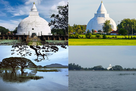
Tissamanharamaya alias Tissa is a bustling town in southern Sri Lanka with a scenic backdrop of the ancient Tissa Wewa, a refreshing breeze that sweeps the town. The breathtaking expanse of paddy fields lying around the town adds much beauty to the town. Located about 38 km northeast of Hambantota, Tissa remained the capital of the ancient Ruhuna Kingdom as early as the 3rd century BC. While being a gateway to the Yala National park, Lunugamwehera national park, Situlpawwa Viharaya, and the Kataragama sacred city, Tissa promises several fine attractions including Tissamaharamaya Dagoba, Tissa Wewa (Lake) Yatala Vehera, and Manik Viharaya, etc.
Hambantota [Sinhala: හම්බන්තොට ] ハンバントター
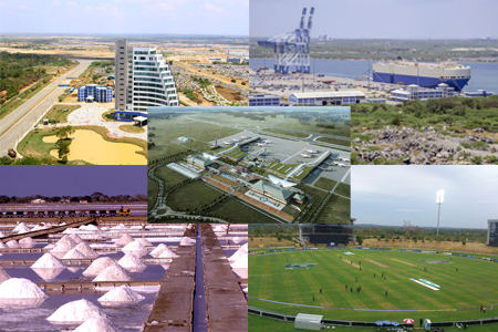
Hambantota was a village in the southern dry zone of Sri Lanka, with minimum rainfall lower than 500 mm annually. The general vegetation of the area is mostly dry zone scrub lands and some dry zone taller trees. The village is originally popular for its salt industry where the coastal lands are at lower altitudes making it easier for the salt pans. There was a small harbor for local fishermen and just 2 reputed tourist hotels for transit purposes.
But today not a village anymore. Hambantota is a different city, an emerging giant in South Asia in near future. Newly built’ harbor getting ready to serve the needs of international maritime lines across. The new port was opened on the 18th of November 2010 with a cost of US$ 361 million. Most infrastructures of the city have already been completed including the express roadway systems to access it and other facilities set up for a modern city, (Unfortunately, the Government between the year 2015 -2019 sold this property to China to recover the lone taken from the Chinese Bank to build this harbor, proving the government’s incapability of management )
The other new facilities already been completed are, International Airport, the Southern expressway makes 3 ½ hour access to Colombo, An International convention hall, A modern district hospital with all facilities, Dry zone Botanical gardens, opened zoo where African animals roam freely, A bird village, Movie filming village, and a 7 star Shangri-la hotel.
Probably Hambantota is going to be the second biggest city after Colombo in near future. Interesting places access from Hambantota, Kirinda Rajamaha Viharaya, Bundala National Park, Kalametiya wet marshlands for wader birds, and all places mentioned above.
Ambalangoda [Sinhala – අම්බලන්ගොඩ] アンバランゴダ
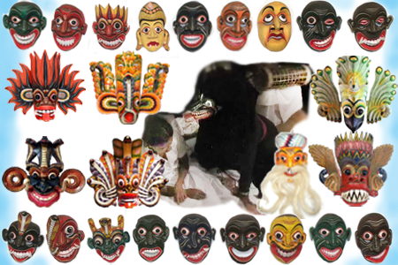
Ambalangoda is a traditional Sinhalese village located in the Galle district of the southern province of Sri Lanka. It is approximately 32 kilometers north of Galle city, situated between Hikkaduwa and Balapitiya. This traditional village is well known for its local cultural heritage being the center of the southern island’s traditional lowland folk dance. These fascinating dance performances are not just a dance of joy and pleasure but it has been continued from generation to generation for thousands of years to heal people suffering from a kind of unknown sicknesses that never be able to cure by any type of medical treatment, it may be subject to talk about exorcism. However, it is still existing within our community.
To my knowledge, these traditional dance performances can be divided into four main different segments. A devil forced healing; Is a kind of dancing drama, that a professional man (shaman) wearing a flesh hunger bear who is representing the King of the Devils “Mahasohona / මහසොහොනා “, and the shaman invite the spirit of devil king himself after starts relief dancing in a wild way by the patient. At last take out the evil spirit from the body of the patient. The other dancing ritual with 18 faces is called “Sani” dance, in which they are believing that persistent illnesses and infectious diseases are inflicted by demons and have identified 18 of them designing different masks for each disease. This cultural white magic event is usually performed by gathering with all villagers on a selected night to bless whole villagers to free them from those diseases.
And the other 2 types are for joy and pleasure forming the audience’s excitement and laughter. Huge monster masks represent different symbolic blessings, such as to prevent from fire by Gini Raksha (fire mask), wealth & prosperity insure by Naga Raksha (cobra mask), and etc., However, these masks are also used in cultural events to perform stories, like a pair of dance performers on the stage, one who is wearing a cobra mask & the other wearing a serpent eagle mask and making peculiar movements into the native drum beat to reveal the life attachment between these two creatures. The “Kolam” or the amuse masked dance tradition uses different types of funny masks, which are selected upon which story to be present on the stage. Also, another classic tradition attached to this drama is marionette puppet shows. But it is unfortunate that these traditions have disappeared from us since television has replaced them gradually in every corner of the villages.
So, this village is almost turned into a modern city than existence these traditional rituals and shows like they happened before, but somehow still the mask-making industry is alive with the help of foreign travelers, who are interested in buying them as a souvenir, and this economic benefit leads to saving some of those traditional families, where they are still existing spread across the southern parts of the Island and scattered around the country
Rathnapura [ Sinhala – රත්නපුර] ラトナプラ
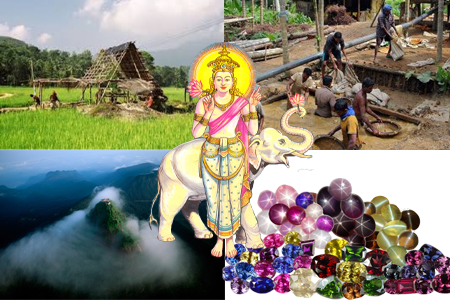
Rathnapura is renowned to the world as a City of Gems situated by the southern lower slopes of central hills surrounded by mountains and the 3rd biggest river “Kalu Ganga” flowing through the city, it is about 85 km southeast of Colombo. The main industry of the city is Gem mining and lapidary works. More than 90% of the gemstones found in the Rathnapura district contribute a significant share of the country’s export revenue. The world’s best Blue Sapphires and finest corundum and many more precious & semi-precious stones are found in the region.
Rathnapura is the home of God Sama and he is the guardian protector of the wealth of the entire region including Adams Peak. There are 2 ceremonies annually that take place with God Saman. The first, by the full moon day of December, God Saman visits Adams peak by a procession and waits at the shrine room on the summit of the mountain till the full moon day of May, allowing devotees to visit safely and venerate the Footprint of the Lord Buddha. After this season God returns to the home shrine in Rathnapura again by a procession. And, the next very colorful bright event is the annual Perahera festival held in the month of September for 13 days at
Matara [Sinhala – මාතර ] マータラ
Matara is famous in local society as the home village of the people of southern Sri Lanka, located in the very south of the island at about 180 km from Colombo, and 85 km from Hambantota.
Dondara, is the most southern peninsula situated in the Matara which is famous for its lighthouse at the southern tip of the island. Dutch period started fort and fort walls are making an identity to the city and few famous beaches, Hummanaya blow hole, whale watching, stilt fishing, and a few old Buddhist temples are unique to Matara.
People from Matara have their own slang words for some words and phrases and they themselves believe that they are a unique local clan.
Negombo [Sinhala – මීගමුව] ミーガムワ
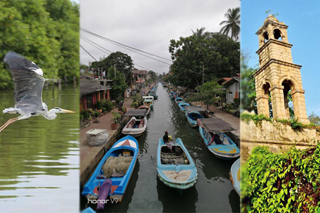
Negombo alias mēgamuwa is located about 40 km north of Colombo on the west coast within the Gampaha district of the western province of Sri Lanka, it is only about 10 km northwest of the Bandaranayake International Airport. Negombo is traditionally a fishing and agricultural village with lots of natural beauty, like rivers, lagoons, a sea with a panoramic beach, coconut fields, marshlands and etc. The city was linked with Colombo by a man-made canal during the Kingdom of Kotte by King Vira Parakramabahu VIII (1484-1518) for the transport of Cinnamon, areca nut, betel leaf, cloves, pepper, and other agricultural products to the Colombo harbor.
With the arrival of Portuguese, Dutch, and English in order from the early 16th century till the late 18th century, Negombo turned into a strategically important place interconnecting transport network system using the waterways. Dutch has developed the canal system to maintain fresh water in the canal during both the high & low tides. English reconstructed and developed the canal improving the linkage between Colombo and Negombo for better transportation of exports from the country.
Today, Negombo is a city that turned into a tourist destination as it is the nearest shore to the international gateway. Hotels from 5 stars to guest houses are common with many varieties for selection, nightclubs, restaurants, and spars available in the hotel road of Negombo.
Interesting places to visit; Muturajawela Marsh Land, Dutch Canal & Gin River Boat ride, Colonial time Churches, Negombo Lagoon boat ride, Fish market and Dutch fortress (prison house), and fishing at sea.
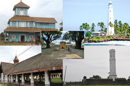
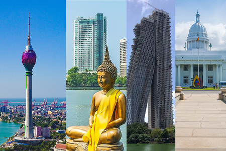
Colombo [Sinhala – කොළඹ ] コロンボ
Colombo is the commercial capital of Sri Lanka. But yet the official administrative capital is Sri Jayawardenapura Kotte, which is situated within the District of Colombo. Colombo alias Kolamba means mango leaves, the traditional people used to refer to the area as wild mangos, and eventually, the local term became Colombo by the occupation of the Portuguese. Central Colombo is still called a fort although there is no fort existing, which was demolished by the English for expanding the city limits in 1870.
Portuguese settle down in Colombo making a fort called “Santa Barbara” by the year 1518, but it was abandoned in 1524. They again built a new fort by 1554 and Colombo city began to develop. Devastating Portuguese built several churches in and out of the Colombo fort destroying Buddhist temples around the area including the very old sacred Kelaniya Temple in close proximity to Colombo. Dutch took over the control of Colombo in the year between 1655 and 56 after a winning battle with Portuguese, they demolished the fort walls partially for development and removed most Portuguese churches. And reformed Dutch Churches in some locations, including the Wolfendahl Church in Colombo, which was built outside of the rampart. Also found some buildings were built outside the fort such as the present Dutch museum at the Pettah by Prince Street.
English arrived in Colombo in 1796, known to have received all assets of the Dutch monarch from a deed. During the English period, they made several strategies to keep control of new local immigrants to the city while they were in the care of the local community, such example could raise here that they place the National General Hospital at the eastern border of Colombo city by the Norris canal preventing the poor man to go inside the city creating a barrio for separate poor and the rich. It is clearly visible even today that the downtown of Colombo is situated outside the Norris canal. Even they made the public cemetery outside the side of the Norris canal.
Since the early period of colonial times, it says that Colombo is a widely mixed culture with many different language speakers such as Dutch, English, Portuguese, Sinhalese, Tamils, Malays, Borah and etc. Even today in the areas like Pettah (Bazar of Colombo) can see many different people living in harmony.
The city emerged in the next century with a completely different identity, even changing the land map of the city and adding a new land on the sea. Skyscrapers already started a competition, and central and local government has been involved to adjust access road facilities and other infrastructures to meet the supply for the demand of the city. The city will definitely increase its population by a few million sooner than the present number which is only 10% of Sri Lanka’s population of 21 million.
By Eranga Suneth Jayasinghe